June 3, 2019
Eyes in the sky: How satellites can monitor infrastructure health
Increasing global population growth and resource exploitation is creating a huge demand for civil infrastructure, including buildings, subways and train lines, bridges, dams, highways and airports. Given the pressure, the engineering, construction and maintenance of such projects is not always well managed, and without careful monitoring, catastrophic failure is anything but an abstract possibility.
4 minutes
Original Content: The Conversation, in partnership with the AXA Research Fund
The August 2018 Genoa bridge collapse, which left 43 dead, is just one example. Another is the January 25 Brumadinho dam collapse in Brazil, which led to at least 237 deaths.
Hidden risks
With the growing awareness of the importance of public safety and infrastructure sustainability, emphasis needs to be on not only the efficient use of resources but also the proper management of built infrastructure to ensure that it remains safe throughout its designed lifespan.
Obtaining early warning of potential disasters is highly complex, mainly because of the extremely wide variety of risks. While there hasn’t been a formal conclusion on the cause of the Genoa bridge collapse, but it was supported by steel cables encased in concrete, and just two decades after its construction, fissures and corrosion were clearly visible. Repair work was scheduled for later this year, but the bridge collapsed before it could start. In the case of the Brazil disaster, the structure was an “upstream tailings dam”, a wall of dirt and silt that held back a reservoir of semi-solid mining waste. With no hard structure, the Brazil dam was inherently unstable and should have been constantly monitored – even over extremely large areas, there can be early warning signs such as subtle ground deformation.
Given the wide variety of infrastructure projects, the range of risk factors is immense. To better monitor them, an interdisciplinary approach is a must. Existing challenges must be addressed and future ones prepared for by focusing on assessment, monitoring, information sharing and risk reduction.
Eyes in the sky
One technology that has considerable potential is satellite-based synthetic aperture radar interferometry, known as InSAR. SAR satellites orbit in a sun-synchronous polar orbit, meaning that the satellite passes over any given point of the Earth’s surface at the same local mean solar time. It has the capability of monitoring large-scale movements of the Earth’s surface over long periods of time, providing a better picture for understanding infrastructural health.
Compared with optical satellites, SAR satellites have continuous, all-weather monitoring capabilities. They emit electromagnetic waves with wavelengths ranging from about one meter to one millimetre, and receive backscattered signals – which are reflection of waves, particles, or signals back to the direction from which they came – after they’re reflected by the Earth’s surface. These indicate the reflectivity of chosen targets as well as their distance from the satellite and each other.
The first civilian SAR satellite was SEASAT, launched in 1978 by NASA and the Jet Propulsion Laboratory. With an image resolution of 25 meters, SEASAT revolutionary at the time, and today’s satellites have spatial resolution down to one meter, and revisit the same spot over time periods as short as a few days. Examples include the TerraSAR-X, COSMO-SkyMed, and Sentinel-1, launched by Germany, Italy and the European Union, respectively.
InSAR can capture the topography of any part of the Earth’s surface, urban or rural, and through the comparison of two images measure the surface deformation between two observation times. The first worldwide digital elevation model – created with data from the Shuttle Radar Topography Mission – was generated in 2000 using InSAR technologies.
By removing topographic contribution, it is possible to extract subtle deformation information, such as land subsidence, infrastructural movements and even what are in effect slow-motion landslides.
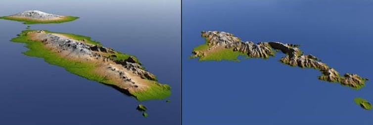
Color-coded perspective views of the independent state of Samoa (left) and American Samoa (right) taken on November 1, 2009, by the Radar Topography Mission. A major undersea earthquake on Sept. 29 that year generated a tsunami that inundated the the southern coasts of Somoa and American Samoa, causing scores of casualties. The data produced can be used to aid researchers and planners in predicting which coastal regions are most at risk. NASA/JPL/NGA, CC BY
The main source of potential measurement errors is “atmospheric delay”, which can slow or shift signals and distort the data captured. However, the most advanced multi-temporal InSAR can mitigate atmospheric delay using multi-baseline images and can measure landscape deformation down to the millimetre level.
Scanning for “urban diseases”
With accelerating urbanisation, infrastructures are being extensively developed, especially those that are partially or entirely underground, such as subways. Abnormal deformation of infrastructure has been called a hidden “urban disease” that must be more closely watched by researchers, authorities, politicians and the public.
Just as CT scans are used to examine the state of a patient’s health under the surface, InSAR offers a way to monitor infrastructure dynamics and build a “health diagnosis”. Images can be used to highlight risk-prone areas, and if unusual surface movements are detected, further investigations can be carried out. For example, if land subsidence is detected adjacent to a subway line, further investigation will be done for individual buildings to see if they’re also affected. This hierarchical system facilitates not only regular overall monitoring at the regional or even national levels but also further detailed investigation of individual structures as necessary.
In practice, two primary challenges remain. First, the number of satellites is limited and the demands high, restricting the ability to acquire timely, high-resolution images. The launch of more satellites is expected to overcome this challenge. Second, sudden changes can occur at any moment – resurfacing projects and sinkholes are just two examples. Advanced algorithms and processing chains are required to better be able to take these into account.
Decision-support systems
InSAR satellites thus provide a powerful way to assess the health of existing infrastructure, even that not visible from space. The deformation information collected can be combined with expert knowledge from other domains, including geotechnical and structural engineering, hydrology, geology and meteorology. Together, they can enhance our understanding of infrastructural dynamics and improve our ability to better diagnose, manage and maintain them.
Dr Peifeng Ma
Know more about his project : Insuring infrastructure safety using satellite monitoring technology
PROJECT PAGE